A key priority for the Irish Sea Rim is to create a comprehensive and nuanced map of the innovation ecosystems and regions comprising the Investment, Innovation, and Enterprise Zone. This detailed map of the whole “supercluster” will be essential to fully deliver the ISR50 Strategic vision and leverage the innovation potential to deliver non-linear increases in sustainable, inclusive, economic growth and societal benefit.
IRISH SEA RIM MAPPING STRATEGIC BENEFITS
The Irish Sea Rim mapping exercise will offer strategic value on multiple fronts including:
- ATTRACTING INVESTMENT: Document the ecosystem mapping to showcase the Irish Sea Region’s assets, centres of excellence, innovation clusters, places, and opportunities to attract investment, talent and partnerships nationally and globally.
- HOLISTIC UNDERSTANDING OF THE REGION: Identify interconnectedness across sectors and ecosystems to understand regional strengths, idiosyncrasies, interdependencies, weaknesses, gaps, and opportunities.
- INFORMED POLICY AND INVESTMENT DECISIONS: Support evidence-based and nuanced alignment of policy and resource allocation, leading to more effective and targeted policies, strategies, and initiatives tailored to regional strengths and needs.
- STRATEGIC COLLABORATIONS: Facilitate and broker cross-border and cross-sector collaborations and sharing of infrastructure, skills pipelines, and supply chains.
- ECONOMIC GROWTH AND JOB CREATION: Support strategic development of the innovation ecosystem to enable creation and growth of new businesses, inclusive wealth creation, and a diverse range of job opportunities.
- SUSTAINABLE AND INCLUSIVE GROWTH: Include places, communities, built and natural environments in mapping alongside traditional economic indicators to ensure inclusive, place-sensitive development which is aligned to sustainability and social priorities across urban, rural, and coastal areas.
- CATALYSING ECOSYSTEMS: Convene diverse stakeholders to surface hidden strengths and catalyse new conversations and relationships, creating momentum for ongoing ecosystem development and co-ownership of regional growth strategies.
- TRACKING PROGRESS: Establish a baseline for key metrics for benchmarking against other entrepreneurial ecosystems and monitoring and reporting on the effectiveness of interventions and polies, supporting accountability and continuous improvement.
MAPPING FRAMEWORK
In the first instance we propose to use an adapted version of Dan Isenberg’s Entrepreneurship Ecosystem model[109], based on a similar approach used by Liverpool Business School in its 2024 analysis of the Liverpool City Region scale up ecosystem[110]. We will also include selected OECD Pillars of Regional Development Policy[111]. The Irish Sea Rim Mapping Framework will align to our strategic operating priorities of Optimising Conditions, Catalysing Innovation, and Driving Impact (Figure 26.1). The exact metrics and information collected will be informed by existing data and co-designed with key stakeholders across the quadruple helix of government, business, academia, and place.
In line with our principles and values of vision-led leadership, partnership, consideration, respect, support, integrity, learning, partnership, inclusivity and excellence (Section 1) we will approach mapping with an entrepreneurial and curiosity-driven mindset, encompassing the wider needs of places and entrepreneurs as well as focussing on the specific attributes of the regional innovation ecosystems.
Figure 26.1: Irish Sea Rim Mapping Framework 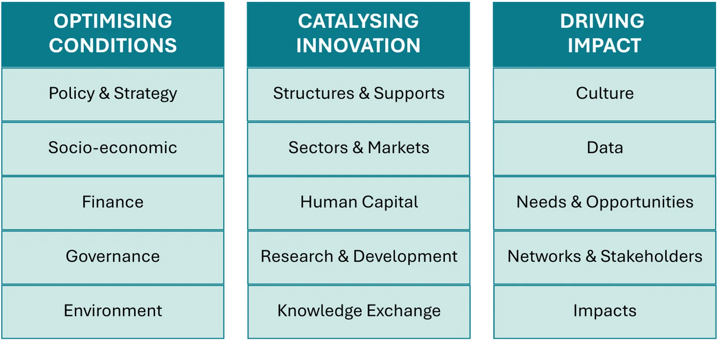
DATA COLLECTION, STORAGE, AND SYSTEMS
Effective systems for data collection and storage are critical, as the Irish Sea Rim map and associated data will underpin many of our operational functions. To manage the information gathered through our multi-faceted mapping methodology, we will establish a robust and secure data infrastructure. This approach is directly informed by the expertise of our Director of Technology, based on experience implementing and overseeing such systems in large-scale organisations, including Citizens Advice.
- DATA STORAGE & SECURITY: The core of our system will be a secure, cloud-based database. This centralised repository will be designed for scalability and will adhere to strict data protection regulations, including GDPR. Access – which can also be granted via API for programmatic access - will be role-based and tightly controlled to ensure the confidentiality and integrity of the collected information.
- DATA COLLECTION & INTEGRATION: All data, whether from surveys, interviews, or desk research, will be fed into the digital database. We will use standardised templates and data entry protocols to ensure consistency and quality across information sources. This will allow for the effective aggregation of both quantitative (e.g., survey results, economic indicators) and qualitative (e.g., interview transcripts, workshop notes) data.
- SYSTEMS & ANALYSIS: This database will integrate with advanced data analytics and visualisation tools. For geospatial analysis, the data will be used in platforms like ArcGIS to create detailed, layered maps of assets, networks, and environmental data. The 'live map' of the Irish Sea Rim will be a dynamic, interactive web-based portal, providing stakeholders with controlled access to relevant, up-to-date information.
MAPPING METHODOLOGY
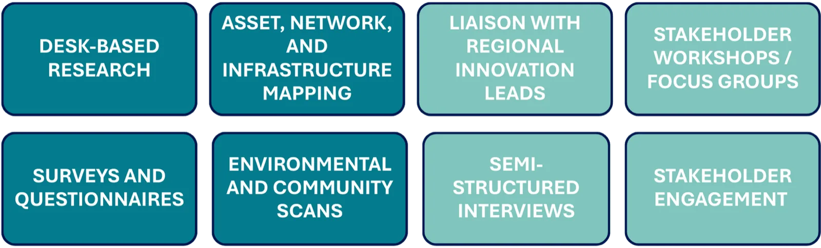
In mapping the Irish Sea Rim, we will employ a range of methods to engage stakeholders, tap into the wealth existing regional mapping data, and collect and collate the information gathered into a powerful and useful resource. Mapping methods may include:
The Irish Sea Rim will work in-house, with infrastructure support bodies (such as the Connected Places Catapult), and with specialised data analytics organisations (such as Growth Flag) to synthesise and analyse data for commonalities, unique strengths and attributes, gaps, needs, and opportunities. We will use these analyses to inform the strategic priorities for Irish Sea Rim, and feed back into regional and national policy development through a series of co-authored White Papers.
We appreciate that across such a large and diverse region, the innovation ecosystem will be subject to constant evolution and change. We therefore regard the Irish Sea Rim ‘map’ as a live database and will update it regularly through our regional representatives and networks to ensure currency.
UK National Electricity Distribution Grid, Heysham (400kv), Lancashire, Image credit: Irish Sea Rim